Dyrskar Pass – Norway’s Forgotten Stone Road Through Icelandic Terrain
Über dieses Abenteuer
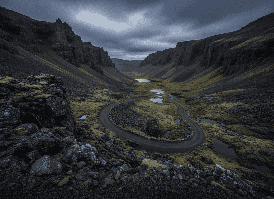
Dyrskar is a high-mountain pass on the border of Telemark and Vestland, known for its unexpectedly volcanic landscape and eerie quiet that feels transported from Iceland. The terrain is dark, jagged, and windswept—more like Iceland than southern Norway—with basalt-like rock formations, scree fields, and a stark, treeless environment shaped by relentless weather.
The Trail
Dyrskar is a high-mountain pass on the border of Telemark and Vestland, known for its unexpectedly volcanic landscape and eerie quiet that feels transported from Iceland. The terrain is dark, jagged, and windswept—more like Iceland than southern Norway—with basalt-like rock formations, scree fields, and a stark, treeless environment shaped by relentless weather. The pass sits at about 1,200 meters elevation, creating an alpine environment where summer is brief and winter conditions persist most of the year. Cutting through this dramatic valley is the old stone postal road from the mid-1800s, an engineering marvel where workers hand-built walls, laid stone slabs, and carved passages to create a reliable route for mail delivery and trade between eastern and western Norway.
What to Expect
Parts of the road remain remarkably intact, with precisely fitted stones and sturdy walls that have survived 150+ years of harsh mountain weather. Walking sections of this historic route connects you tangibly to the era when crossing mountains was serious undertaking requiring days of travel and considerable hardship. The area remains almost untouched by modern development, offering a rare stretch where history and geology merge dramatically. Dramatic cliffs rise on both sides of the pass, old road tunnels (some still passable, others collapsed) pierce through rock barriers, and wide views extend over barren rock plains that change color with the light—golden at sunrise, steely gray under clouds, warm at sunset.
Planning Your Visit
The silence is profound, broken only by wind and occasional bird calls. Access is via the modern Rv11 highway which parallels the old road, with opportunities to park and explore on foot. Summer (July-September) offers the only reliable ice-free conditions. The area is popular with Norwegian history enthusiasts and geology students but remains unknown to most international visitors. Bring warm layers as weather can be severe even in summer.
Never get stuck for words in Norwegian
Someone speaks to you in Norwegian? TalkBuoy listens in real time and suggests exactly what to say back. Your AI companion for travel conversations and language learning.
Affiliate-Offenlegung Diese Seite enthält Affiliate-Links. Wir können eine Provision von Käufen erhalten, die über diese Links getätigt werden.
Entdecken Sie Telemark / Vestland border mit lokalen Guides
Vermeiden Sie Planungsstress! Durchsuchen Sie Tausende verifizierte Touren, Aktivitäten und Erlebnisse. Von Nordlichtexpeditionen bis zu Fjordkreuzfahrten - finden Sie das perfekte Abenteuer.
Hidden Norway nimmt an Affiliate-Marketing-Programmen teil, einschließlich GetYourGuide und anderen. Das bedeutet, dass wir möglicherweise eine Provision erhalten, wenn Sie Touren buchen oder Käufe über unsere Affiliate-Links tätigen. Dies verursacht keine zusätzlichen Kosten für Sie und hilft uns, weiterhin kostenlose, qualitativ hochwertige Inhalte über Norwegens verborgene Schätze bereitzustellen. Wir empfehlen nur Dienste und Erlebnisse, von denen wir glauben, dass sie Ihr norwegisches Abenteuer bereichern werden.
Standort
GPS-Koordinaten
59.8235, 7.2015