Bjørnfjell Plateau – Arctic Highlands Above the Border
Acerca de esta aventura
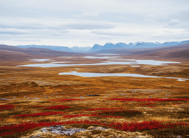
Bjørnfjell is a broad highland plateau east of Narvik at approximately 500-600 meters elevation, where low mountains, open tundra, and scattered lakes stretch toward the Swedish border in an expansive Arctic landscape that feels endless. The plateau marks the transition zone between Norway's dramatic coastal mountains and Sweden's rolling northern forests.
The Trail
Bjørnfjell is a broad highland plateau east of Narvik at approximately 500-600 meters elevation, where low mountains, open tundra, and scattered lakes stretch toward the Swedish border in an expansive Arctic landscape that feels endless. The plateau marks the transition zone between Norway's dramatic coastal mountains and Sweden's rolling northern forests. The terrain is gentle but exposed, with long sightlines extending for kilometers across rolling ground where you can see weather approaching from vast distances—a rain squall moving across the plateau becomes visible 30 minutes before it arrives. This creates a strong sense of space and vulnerability to the elements that characterizes high Arctic environments.
What to Expect
The bedrock is ancient, worn smooth by glaciers, and covered with tundra vegetation adapted to severe conditions—lichens, mosses, dwarf birch, and hardy grasses that can survive brutal winters and short growing seasons. Scattered lakes and tarns dot the landscape, their waters reflecting the massive skies. In autumn (late August through September), the ground turns spectacular red and gold with berries (cloudberries, blueberries, crowberries) and moss creating a living carpet of color that draws berry pickers and photographers. Winter brings deep silence and snow, transforming the plateau into a white wilderness where cross-country skiing and snowmobiling are popular activities, and the occasional reindeer herd might be the only movement visible for miles.
Planning Your Visit
The area is crossed by the historic Ofoten railway line which carries iron ore from Kiruna's mines in Sweden to Narvik's ice-free port, with Bjørnfjell station sitting at the Norwegian-Swedish border. The combination of accessible plateau terrain, dramatic vistas, and relative lack of crowds makes this excellent for hikers seeking big-sky experiences without technical challenges. Summer hiking offers wildflowers and extended daylight. Weather can change rapidly—bring layers and rain protection year-round. The plateau is accessible via the E10 highway with numerous pullouts for parking. No facilities exist on the plateau itself.
Never get stuck for words in Norwegian
Someone speaks to you in Norwegian? TalkBuoy listens in real time and suggests exactly what to say back. Your AI companion for travel conversations and language learning.
Divulgación de afiliados Esta página contiene enlaces de afiliados. Podemos ganar una comisión por compras realizadas a través de estos enlaces.
Descubre Nordland con guías locales
¡Evita el estrés de la planificación! Explora miles de tours, actividades y experiencias verificadas. Desde expediciones de auroras boreales hasta cruceros por fiordos - encuentra la aventura perfecta.
Hidden Norway participa en programas de marketing de afiliados, incluyendo GetYourGuide y otros. Esto significa que podemos ganar una comisión cuando reservas tours o realizas compras a través de nuestros enlaces de afiliados. Esto no te cuesta nada adicional y nos ayuda a seguir proporcionando contenido gratuito y de calidad sobre las joyas ocultas de Noruega. Solo recomendamos servicios y experiencias que creemos que mejorarán tu aventura noruega.
Ubicación
Coordenadas GPS
68.4263, 18.0639