Skardsalen Valley – A Lost Alpine Valley Without Roads
À propos de cette aventure
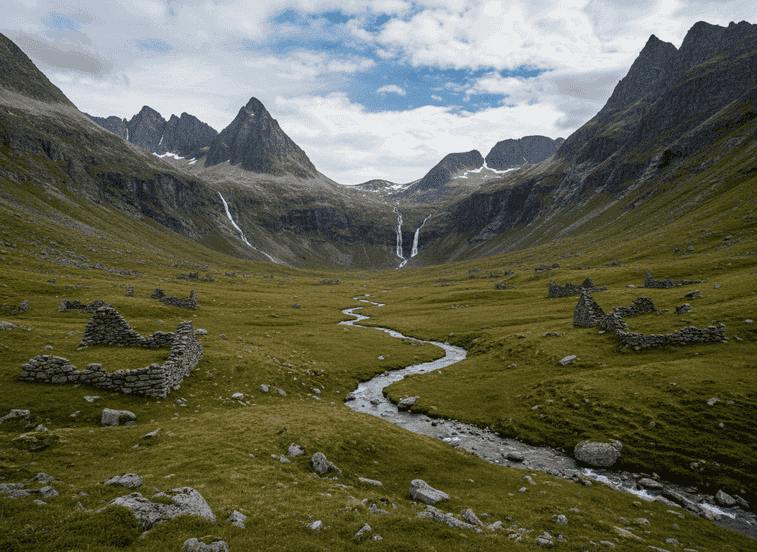
Skardsalen is a remote alpine valley in Sunndal with no road access, only reachable on foot via a moderately demanding trail that deters casual visitors and preserves the valley's pristine character. The hike in covers approximately 8-10km from the nearest road access, crossing streams, ascending through birch forest, and finally emerging into the valley proper.
The Trail
Skardsalen is a remote alpine valley in Sunndal with no road access, only reachable on foot via a moderately demanding trail that deters casual visitors and preserves the valley's pristine character. The hike in covers approximately 8-10km from the nearest road access, crossing streams, ascending through birch forest, and finally emerging into the valley proper. Once home to summer farms (støls) where families brought livestock for high-altitude grazing during brief mountain summers, the valley is now largely abandoned—a transition that occurred in the mid-20th century as traditional mountain farming became economically unviable. Stone foundations of old farm buildings remain, their walls still standing but roofless, slowly being reclaimed by vegetation.
What to Expect
Open grazing land maintains a park-like quality, kept clear by occasional sheep still pastured here, creating meadows dotted with wildflowers in July and August. The valley is surrounded by sharp peaks with distinctive profiles, their slopes streaked with waterfalls during snowmelt season, and the sense of enclosure creates a hidden-world atmosphere. The mountain amphitheater concentrates sunlight and shelters the valley from the worst weather, explaining why farmers chose this remote location. Skardsalen feels like a forgotten pocket of Norway where nature has quietly taken over but human presence still echoes in the landscape.
Planning Your Visit
Even experienced hikers rarely venture here as it requires commitment—the round trip makes a full day, there are no facilities, and navigation requires map skills as marking is minimal. The trail can be muddy and stream crossings may be necessary depending on water levels. Best visited July through September when snow has cleared and weather is most stable. The solitude and atmospheric blend of natural beauty with abandoned cultural landscape creates a powerful sense of stepping back in time. Photographers appreciate the dramatic peaks, waterfalls, and historic farm ruins. Pack all food, water, and emergency supplies.
Never get stuck for words in Norwegian
Someone speaks to you in Norwegian? TalkBuoy listens in real time and suggests exactly what to say back. Your AI companion for travel conversations and language learning.
Divulgation d'affiliation Cette page contient des liens d'affiliation. Nous pouvons gagner une commission sur les achats effectués via ces liens.
Découvrez Møre og Romsdal avec des guides locaux
Évitez le stress de la planification ! Parcourez des milliers de visites, activités et expériences vérifiées. Des expéditions d'aurores boréales aux croisières sur les fjords - trouvez l'aventure parfaite.
Hidden Norway participe à des programmes de marketing d'affiliation, y compris GetYourGuide et d'autres. Cela signifie que nous pouvons gagner une commission lorsque vous réservez des visites ou effectuez des achats via nos liens d'affiliation. Cela ne vous coûte rien de plus et nous aide à continuer à fournir du contenu gratuit et de qualité sur les trésors cachés de la Norvège. Nous ne recommandons que des services et des expériences qui, selon nous, amélioreront votre aventure norvégienne.
Emplacement
Coordonnées GPS
62.6594, 8.5701